Is there such a thing as Scotland’s sunshine coast? Well, Moray, in the ‘rain-shadow’ of the Grampian mountains pretty much fits the bill. Honestly. Especially the favoured coastal strip, tucked below the hills, beyond the reach (mostly!) of the rainy south-westerlies off the Atlantic.
So where exactly is Scotland’s sunshine coast? It’s a bold claim! You thought it was never sunny here?
It’s simple. Mostly Scotland’s prevailing winds come from the south-west, off the Atlantic. So-o, what area lies beyond, to the north-east of the mountains, notably the Cairngorms, making it sheltered, drier and sunnier than the average? Answer: Moray.
Coastal Moray Is Scotland’s Sunshine Coast
Admittedly, bits of East Lothian and also stretches of Fife (both, note on Scotland’s east side) are comparatively dry too, though nearer major centres of population and thus more crowded.
But Moray? ‘Up there’ on the shore of the Moray Firth. Well, it’s pretty unspoilt, down by the sea. And dry.
The little resort town of Lossiemouth, for instance, has 672.7mm of rain per year. (That’s 26.5 inches in old money.) Average for the whole of Scotland is 1571mm (61.8 inches). The Met Office says so.

Here’s A Snapshot
Of The Moray Firth Coast
Let’s image that it’s May and the gorse is out. It smells of coconut. Above the gentle splash of the tide, you can hear the squeaky-scratchy song of whitethroats.
Pink thrift is in flower underfoot and there’s some crowberry too (which a friend says ‘smells of mountains’ – I love that).
Lyrical, eh? Anyway, there’s more. You’ve got the coastal path to yourself. You’ve nailed the place to get morning coffee…or, no, make that lunch…maybe try our local fish soup called Cullen skink.
(One of the best places to eat it is at Bijou By The Sea at Portessie one mile from where this Findochty picture was taken).
Now, would you really want to be away in the far west of Scotland on a warm and sunshiny day like that – BEING EATEN ALIVE BY MIDGES? Your call.
My paintings of Cullen and the Moray Firth
I enjoy painting some of my favourite Scottish views. Here are few of Cullen and area. I sell art prints of these paintings. Check out my art website too – where you can buy fine art prints of Scottish landscapes and seascapes.


Moray’s Coastal Villages
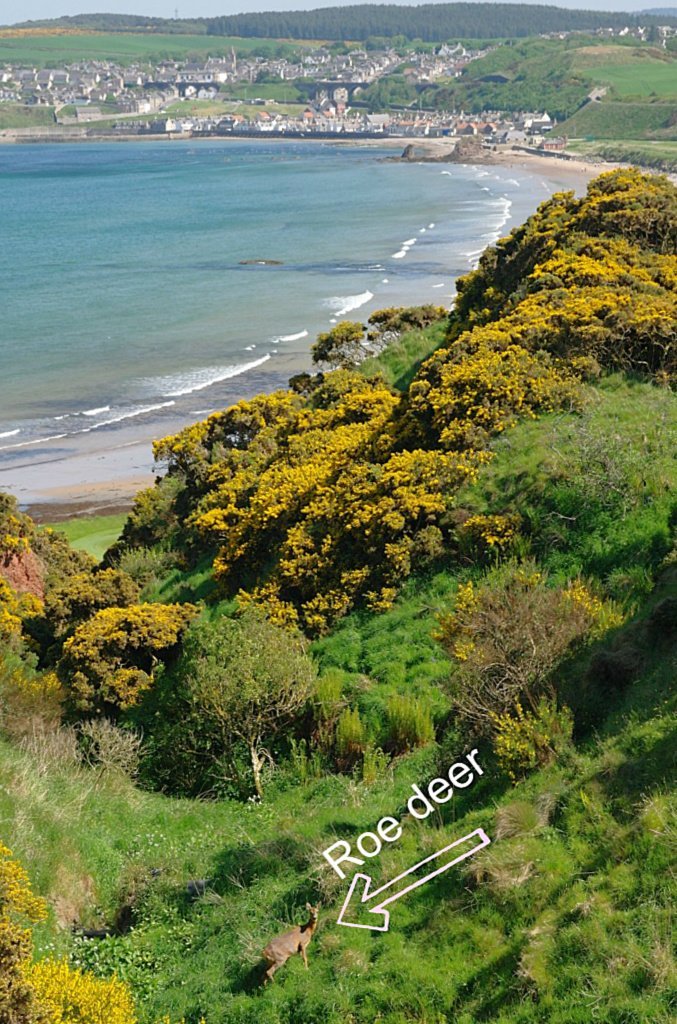
Let’s sweep west to east along Scotland’s sunshine coast, starting with the slightly posh village of Findhorn. (Look, it’s got a yacht club, OK? So it follows…)

In this photo, the tide is high, there’s a not a lot of sailing activity as it’s a weekday, but there’s a grand sweep of a bay to mess around in if you’re a bit boaty. And there’s a fine and endless beach just a moment from here.
Plus nice places for pub meals, drinks, cake, etc – as well as a couple of hotels, B&Bs and cottages. It’s all very pleasant on the sunshine coast.
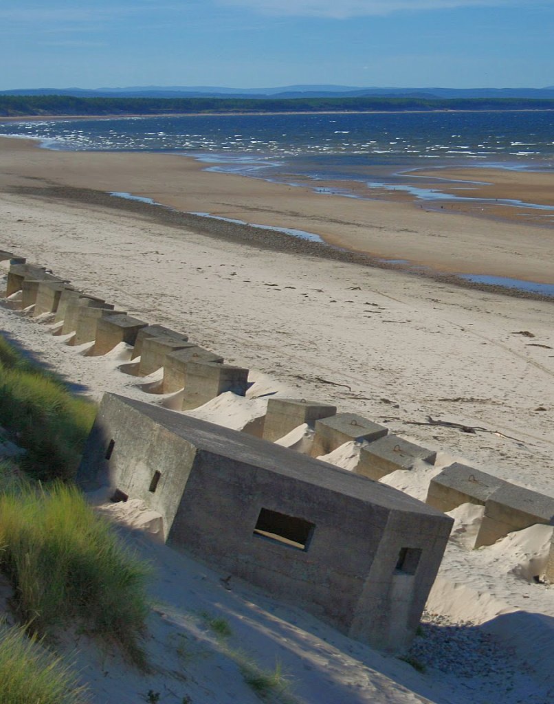
Relics Of Conflict – Burghead Bay
Midway between Findhorn and Burghead, note a couple of characteristics of Roseisle Beach / Burghead Bay: the trees (Forestry Commission) grow down to the shore and there are extensive WWII defences, as this picture shows.
The shoreline hereabouts was considered by the military to resemble a sector of Sword Beach, one the designated beaches for the Normandy Landings of WWII. Hence a variety of rehearsals were carried out all along the coast here, notably by the 79th Armoured Division.
Though these exercises were carried out comparatively successfully, it is said that at least five tanks (other sources say eight) were lost during practice launches offshore.
The ‘swimming tanks’ were top secret, so reports are scarce – but these Duplex Drive Valentine tanks lie in the waters of Burghead Bay, towards the Findhorn end, with one (at least) a designated war grave.
By the way, here’s a good day tour from Inverness that gives you real insight into this slightly ‘off the beaten track’ part of Scotland…
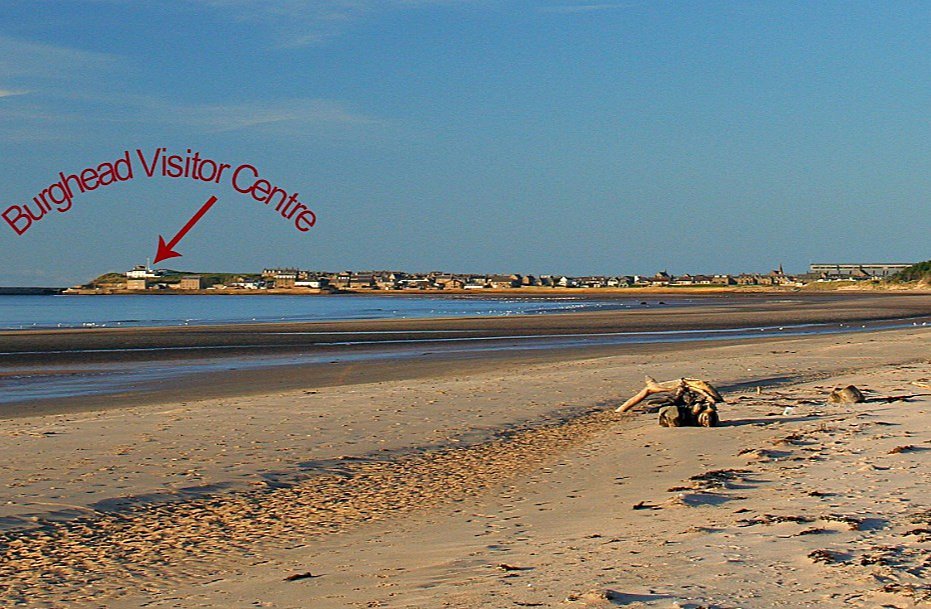
Burghead – The Capital Of Pictland, on Scotland’s Sunshine Coast
If – instead of driving – you walk east from Findhorn, on the beach or in the forest, after a couple of hours hiking (or less), you will reach the promontory town of Burghead.
It’s a ‘planned town’, meaning it was laid out to the local landowner’s improving plan in 1805-9.
Unfortunately, in clearing the site, the builders destroyed a large portion of what would otherwise have been Scotland’s largest and probably oldest Pictish Fort, which straddled the headland.
Discover more at the excellent local heritage centre, housed in an old Coastguard Lookout, right on the tip of the headland. Great for dolphin-watching in the Firth too. (Hey, how come we got this far without mentioning dolphins?)
You can grab a snack at the Bothy Bistro in Grant Street.
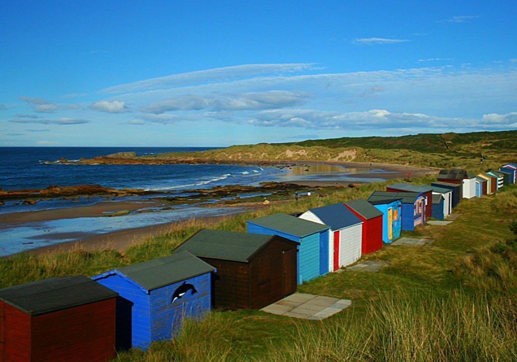
Where There’s Life There’s Hopeman
This little town has a lovely shoreline, with beach huts an unusual feature for this part of Scotland. You could treat yourself to an ice cream here and go for a stroll.

Walking eastwards towards Lossiemouth brings you to a more rugged section of the coastline, maybe a kind of ‘Dinosaur Coast’ as various fossils are sometimes unearthed here by the local quarry.
(Strictly speaking, most of them are pre-dinosaur, but obviously, as you can see from a picture here, at least the beasties had evolved feet.)
This chunk of rock lies near the path. It’s too big to carry off, so don’t even think about it.
But you can see other footprints on the Hopeman sandstones on the shore, including evidence of ‘tail-drag’. No, really.
Lossiemouth – The Antibes Of The Moray Firth?
Slightly tongue-in-cheek here: (I may or may not delete that heading.) The town of Lossiemouth carries that air of well-scrubbed neatness that former fishing towns have in this area. The harbour is a marina. Big wide beaches roll out east and west.
It’s even popular with aircraft spotters, as the local fast jet base can be very active. And you can see round the community-owned Covesea Lighthouse.
If you want just one gee-whizz fact about the place, the local business association website tells us that ‘the dunes in Lossie’s East Beach were made using old railway carriages to protect the seatown from heavy seas’.
I think that even beats the story that the old Tory buffers in the local golf club banned Lossiemouth-born Ramsay MacDonald from joining, because he was a Labour Prime Minister. Ah! parish pump politics…

OK, the sunshine is a little uncertain on this early spring day, looking east from Lossiemouth.
Actually, nowhere have I said this area is sunny all the time! (Said he, just a tad defensively.)
(Pictured here/above) Can’t see any railway carriages sticking out of those sand dunes (see main text). Estuary of River Lossie, looking to Spey Bay and eventually the town of Buckie. (Invisible in this picture, but trust me, it’s there.)
The ‘Lossie Hole’
Before we sweep on eastwards, there’s one more thing about Lossiemouth.
It’s some more evidence for Moray’s pleasant climate and is linked to the story of RAF Lossiemouth. Originally a WWII airfield, it is sometimes described as the busiest fast jet airfield in the UK.
Captain Eric ‘Winkle’ Brown was the Station Commander in charge 1967-70 and he writes of his time there in his fascinating autobiography ‘Wings on my Sleeve’.
He comments especially on the local meteorology, using the expression ‘The Lossie Hole’. (This notion, at time of writing, is yet to appear in local tourism literature, as far as I know).
He was referring to the way that when cloud cover was a problem, conditions for flyers could often be better around the base on the shores of the Firth.
He explains this as the warmth of the Gulf Stream meeting the cold waters of the Caledonian Canal, forcing the air to rise. This happens just offshore.
I couldn’t possibly comment on the meteorology of this – though I prefer to think that it’s the rain-shadow effect of the hills to the south.
However, the late Captain Brown flew 487 different types of aircraft in his extraordinary life and I only get the occasional hop as a Ryanair passenger – so he must have known a lot of stuff about weather.
Whatever the reason for this phenomenon, Brown insists ‘The famous Lossie Hole was no myth, as many anxious aviators could testify’.

Next, Spey Bay, Portgordon And So To Buckie
Anyway, are we nearly there yet? No, there’s still a ton of places to enjoy. There’s Scotland’s longest storm beach at Kingston-upon-Spey, where the shingle runs for miles.
There’s the estuary of the River Spey by Spey Bay – a popular place for dolphin spotting plus a visit to the Scottish Dolphin Centre.
Often overlooked and en route to Spey Bay, are the scattered remnants of RAF Dallachy, with its memorial. More information on that link.
Onwards and east runs the big shingle bank, past Kingston, Spey Bay and towards the wee Buckie satellite of Portgordon.
Unusual for the Firth, with its well-kept little ports, this village has a harbour that has an air of having seen better days.
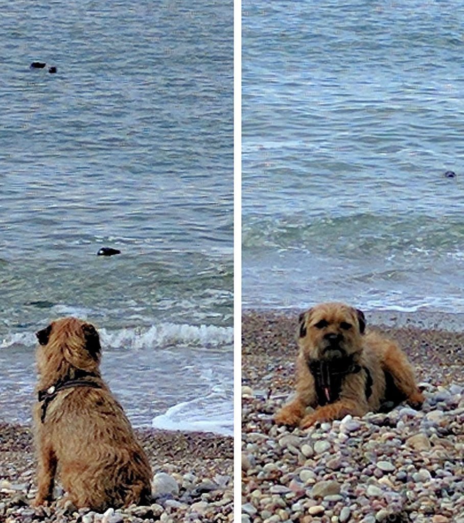
But it makes up for it with plenty of places on either side of the harbour to view seals, which loll about seemingly without a care in their fishy world.
Mostly the visitors watching the local seals show some respect, but there is the occasional moron who gets too close with their phone. Probably trying to take a sealfie.
Ospreys fly down from the River Spey on morning and evening fishing trips along the coast. Most visitors don’t notice as they are ogling the seals instead.
As for the local centre of Buckie, nobody could say it’s picturesque.
However, the late Victorian houses especially north-west of the centre, into Buckpool, are proper, substantial and solid, with their stonework defying Presbyterian dourness with the occasional flash of decoration.
Well worth a stroll if you are interested in vernacular architecture.
Buckie’s commercial harbour is interesting and on the main street there are proper little shoppies.
Visit the local bakers or get some fish and chips. Friendly too.
Findochty, Portknockie And Cullen
Thanks to various shades of hard-wearing outdoor paint on walls and windows, we soon start to do picturesque again.
Here’s where you see the Moray Firth tradition of painting the stonework on older houses. Sometimes even the mortar between the stones is picked out and the result is very distinctive.

Findochty comes next, on this eastward review. Pronounce it ‘finn-ECH-tae’ or the local folk (of which thankfully there are still a few) will laugh and throw stones at you. Only kidding. Good colours here, down by the waterfront.
Next comes Portknockie, with its funny wee harbour tucked below steep green slopes. The local folk (of which thankfully etc etc) are known as ‘Knockers’.

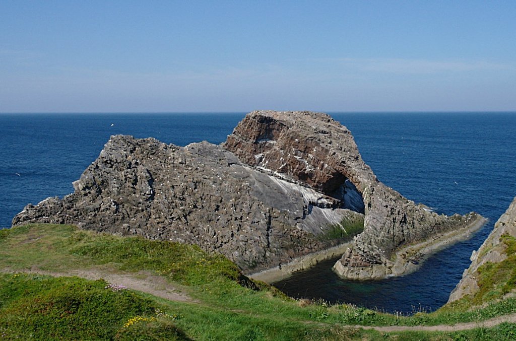
Portknockie is best known for its proximity to the Bow Fiddle Rock.
I suppose The Bow Fiddle serves as a Moray Firth icon. This rock formation of sea-eroded quartzite has a variety of explanations for its name, including the obvious one: uhmm, it resembles a fiddle bow.
(Then why isn’t it ‘Fiddle Bow Rock’?) I think I may start calling it ‘Whale Tail Rock’. That’s what it looks like to me.
The Bow Fiddle Rock is OK, but the short stretch of coast between there and the handsome little town of Cullen is pretty special.
Steps lead down the cliffs near the BFR, and you can walk along the ‘singing sands’. (They squeak – it’s the quartz grains rubbing together.)
Or you can have some high level views by taking the old railway trackbed that leads over the Cullen viaducts.
Cullen is charming. Below is the old higgledy-piggledy picturesque sea-town. Above is the handsome early 19th-century planned town.
Oh, and above the viaducts are the ice-cream shop, plus a selection of antique or trash n treasure shops, also a hardware store (always a good sign!), cafes, and everything you’d want for a leisurely stroll around.
And, in common with the neighbouring villages to the west, it always looks so well-scrubbed – at least, I think so!

And, if you go down to the harbour and walk along the shore, past the (surprisingly emotional) Pets’ Graveyard, you can walk for mile after rugged rocky mile with a few surprises on the way – the least surprising of which is finding yourself in Aberdeenshire.
But that’s for another day. Or page.
************************************
By the way…

Why Moray Is Pretty Dry
You know about rain-shadow? It’s applied to an area in the lee of high ground, sheltered from prevailing winds.
Basically, rain-bearing clouds dump moisture on the hills before reaching the favoured area beyond. Consequently, that area is drier and milder.
Johanna says I sound like a geography teacher, so I relegated this map to the foot of the page. And I’m sure you’re grateful.
OK, three things to interest you…
Where are the best places to see dolphins around the Moray Firth.
With clear skies, the Moray Firth can be a good place to see the Northern Lights. If you’re lucky. And it’s winter!
And just to clarify. Is Moray really in the Highlands?
Still here? Well, take a few moments to watch this salty, blue, splashy, buoyant moment on the Moray Firth coast with the tide rising. Like me, you’ll probably get the place to yourself…